Projects Undertaken by Britannia Archaeology Ltd
A Summary of past projects undertaken by Britannia Archaeology Ltd.
2016
August 2016
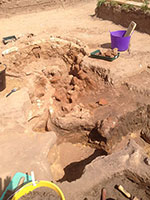
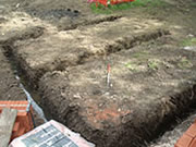
Aylsham Roman Project - Community Dig
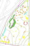
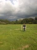
We are delighted to have participated in the Aylsham Roman Project community dig, hosted by Mr Peter Purdy at Woodgate House in Aylsham. Building on earlier work, Britannia Archaeology led the fieldwork for the Project and the many dedicated and hard working volunteers uncovered two Roman pottery kilns with many thousands of associated finds including coins, bronze metal work and of course, tonnes of pottery! Earlier features including ditches and pits were also uncovered showing several phases of activity most likely associated with an affluent villa complex. The main villa building is thought to be located around 100m to the west and geophysical surveys in adjacent plots have revealed numerous enclosures and tracks leading away from it. There are many more seasons of work to come and you can keep up to date with the latest development on the Aylsham Roman Project webpage and Facebook page
2014
November 2014
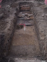
The White House, Capel St Mary, Suffolk
Our recent open area excavation in Capel St Mary, Suffolk uncovered a rare example of a an early Roman corridor villa building as well as earlier Iron Age settlement activity. The villa was constructed in the middle of the 1st century AD and comprised a rear corridor and part of a wing to the north which contained a large room and smaller corridors. The room and one of the corridors showed evidence of a stone mosaic and ceramic tessellated floor surfaces and fragments of well preserved painted wall plaster were recovered from later Roman features that post-date the destruction of the building. The building fell into disuse and the stone masonary and building materials were removed by the middle of the 3rd century AD and were likely reused elsewhere. The remains were quite badly truncated by this 'robbing' process and by a later post-medeival building which stood on the same site. Post excavation analysis is on-going and a publication report will be produced later in the year.
June - July 2014
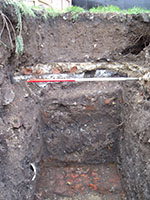
Sadds Wharf, Station Road, Maldon, Essex
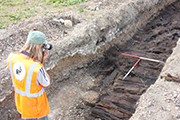
In summer 2014 our evaluation project at Sadd’s Wharf, Maldon, Essex Wharf revealed some very interesting features and geological data. A timber causeway discovered in one of the trenches is a fascinating feature and provides important information on not only the local environment in the post–medieval period but also the construction methods associated with post medieval timber causeways of which there is very little known. The tree species used in the construction of the causeway included Oak and Elm. The presence of iron fittings in the timbers suggested that these were reused from offcuts from timber processing in the area. The site would have been marshland in the early and middle post–medieval period and the causeway was constructed to allow the locals to traverse this tricky terrain between Maldon and Heybridge, where the marsh was higher, wetter and more difficult to navigate than further up the River Chelmer.
January 2014
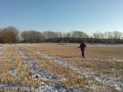
Land North of Broom Hill Road, Lakenheath, Suffolk
Our most complex desk-based assessment to date looked at this area of Lakenheath in Suffolk. The predominant archaeological potential relates to upper Palaeolithic activity associated with the Bytham River dating to nearly half a million years ago. The Bytham River was once a huge river that crossed the midlands and east Anglia, it was removed by glaciers during the Anglian Glaciation around 450000 years ago. It is known to have been a major migration route and its associated surviving gravel deposits provide some of the earliest evidence for the occupation of Britain. Specialist reports on the Quaternary deposits, finds and an aerial photography assessment were provided by Dr Chris Green at QUEST (Reading University) and Alison Deegan.
January 2014
Land at Brackensghyll, Back Lane, Sedbergh
Detailed geophysical survey project using both our gradiometer (Bartington) and an earth resistance meter (RM85) on a site located in the beautiful Yorkshire Dales National Park. The results from both instruments correlated well, revealing several linear and discrete features that probably relate to post-medieval landscaping activity. The project was conducted with the assistance of Chris Healey at Minerva Heritage in Lancaster and is our furthest away from home so far!
2013
November 2013
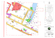
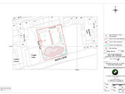
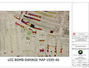
214 Upper Richmond Road, Putney, London
The latest in a long line of London desk-based assessments focused on the busy Upper Richmond Road area of Putney. Located just off the High Street, the site was shown to have a moderate potential for sub-surface archaeology dating to the Romano-British period and a high potential for late 19th century and 20th century remains. The potential for all other periods was considered to be low as the historic maps show that the site remained in agricultural use until the late 19th century. Three phases of building were identified after 1890 and the London County Council (LCC) Bomb Damage Map (pictured) shows that the site was destroyed during WWII.
September 2013
The Rifles Public House, Swan & Pike Road, Enfield
A five trial trench evaluation and borehole assessment that had the potential to reveal post-medieval remains associated with the world renowned rifle factory in Enfield. The evaluation recorded five phases of activity, two of which related to the natural deposition of layers associated with the River Lea and the formation of marshland around it, and three post-medieval building phases. The borehole data was analysed by Steve Boreham at Cambridge University and was useful in building up a picture of the natural evolution of the river deposits, which included a calcareous tufa knoll formed from a spring that often traps material associated with Mesolithic environments. A second phase of trial trenching is due in early 2014.
July 2013
King Harry Lane, Verulamium Park, St Albans, Hertfordshire
A detailed fluxgate gradiometer survey project in the prestigious archaeological area of Verulamium Park (St. Albans) aimed to identify archaeological features in advance of Thames Water's work on the undergound sewer system. Despite the huge potential to find Iron Age and Roman remains associated with the important city of Verulamium, the results were inconclusive. This was most likely due to the area's close proximity to the River Ver (located approximately 100m from the centre of the survey grid) and a build up of alluvial deposits which could mask potential archaeological anomalies. The relatively high magnetic background of the site was also thought to prevent weak, low contrast anomalies from being detected. However the opportunity to work at such a world renowned site was a priviledge and a great start for our newest employee Martin Brook! Further field work to come.
May 2013
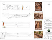
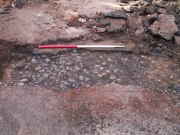
Toppesfield Hall, Hadleigh, Suffolk - Monitoring
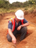
A watching brief was placed on the construction of an external wall and foundations for two cartlodges during the renovation of this well known building in Hadleigh. We identified the remains of an old boundary wall which was present on the 1839 Tithe map, but had been removed by 1885 when the first OS map was produced. The original extent of the existing pond was also revealed during the excavation of footings for the south cartlodge, which proved complicated as depicted in the photograph.
April 2013
Brickfield Stud, Exning Road, Newmarket, Suffolk
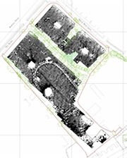
A fluxgate gradiometer survey undertaken on 11 hectares of short cropped grass paddocks at Brickfield Stud, revealed a wide range of anomalies, the majority of which were interpreted as archaeological in origin. Parallel straight double ditch type anomalies were interpreted as a potential Roman road, along with similarly aligned perpendicular linear ditched enclosures that could prove to form a 'ladder' settlement. Another intriguing positive rectangular or possibly oval anomaly was interpreted as a possible structure or barrow. Other discrete anomalies indicative of pit type features, linear trends of possible agriculture origin and broad positive anomalies of probable geological form were also recorded. Possibly our most successful geophysics project to date.
April 2013
Land to the Rear of 84 High Street, Chatteris, Cambridgeshire
A small trial trench evaluation bounding the High Street in Chatteris revealed activity dating back to the Roman period (a small sherd of residual pottery), although the earliest features encountered were medieval. Comprising two pits associated with domestic waste disposal and containing pottery made in Norfolk known as Grimston Ware, fragments of medieval brick and pig bones. A small square brick structure dating to between the 17th and 19th century AD was located in the centre of the trench and may have been the base of chimney or small oven. An opaque glass seal, reading ‘Jane’ in reverse was found at the base of the chimney/oven and is thought to date from 1810 - 1830.
March 2013
125 High Street, Colliers Wood
A trial trench evaluation in south-west London adjacent to the Roman road known as Stane Street and in the grounds of the Brown & Root Tower. One deep trial trench and three test pits revealed three main phases of activity comprising modern development associated with the construction of the existing tower, 17th – 19th century AD activity including a partially surviving topsoil and a brick surface and finally two alluvial layers of indeterminate date. The site had suffered significant truncation from both 19th and later 20th century development. Pollen analysis of the alluvial layers was also undertaken, but unfortunately no useful palaeoenvironmental data could be obtained due to intense oxidisation.
March 2013
Bourne Hill, Wherstead, Suffolk; Geophysical Survey
Detailed fluxgate gradiometer survey was undertaken on 2 hectares of land ahead of the proposed development of a building complex. Located to the south of a known Iron Age and Roman settlement, the survey was successful in locating anomalies of a probable archaeological origin. The most interesting of which were two curvilinears that are possible ring ditches or drip gullies, and some discrete positive anomalies that may be rubbish pits, these anomalies will be targeted by a subsequent trial trench evaluation.
January 2013
Great Glemham, Suffolk; Geophysical Survey, December 2012
Detailed fluxgate gradiometer survey undertaken over 34 hectares of land comprising two fields on a former Second World War American airbase ahead of the construction of a solar farm. The airbase was decommisioned in June 1945 and then demolished, returning the fields back to agriculture. However not all of the remains of the airbase were completely removed and anomalies demarcating the remnants of the former runways, aircraft dispersel areas and airbase drainage systems were recorded in the dataset.
2012
November 2012
Kings Head, Beccles, Suffolk; Archaeological Monitoring
A watching brief was undertaken on a 17th century coaching inn and stables. A surviving small area of a cobbled stone surface abutted by brick rubble foundations were recorded. These overlay an older brick surface dating to the early 19th century which in turn sealed a pit containing a timber post (not in situ) and CBM (ceramic building material) demolition rubble. Earlier timber structures were demolished and replaced with brick structures and a rough cobbled surface in the early to mid 19th century. These in turn were demolished in the 20th century and replaced first with a layer of tarmac and then later by a concrete surface. The only surviving evidence of an earlier structure was the re-deposited timber post.
December 2012
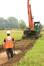
Stoke Ferry, Norfolk, Trial Trench Evaluation, July
Archaeological trial trench evaluation on a site near Stoke Ferry, Norfolk revealed prehistoric activity on the edge of the Wissey Embayment. Several locations just off the high ground leading into former marshy areas appear to have been used for rubbish disposal over 2000 years ago. These 'midden deposits' have yielded good quantities of pottery and burnt and butchered animal bone, giving an insight into the nature and date of human activity within the area.
September 2012
Euston, Suffolk; Geophysical Survey
Detailed fluxgate gradiometer survey was undertaken on 6 hectares of land ahead of the proposed development of an agricultural reservoir. The survey was successful in locating anomalies that were subsequently targeted by trial trenching. Two intriguingly shaped areas of magnetic disturbance were found to be brick kilns. Also present on site were two ponds that may have initially been excavated to recover clay for manufacturing the bricks fired in these kilns.
August 2012
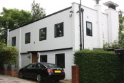
Fleet House, Admirals Walk, London; Desk-Based Assessment
A desk-based assessment undertaken on a property in Hampstead ahead of its demolition and the subsequent construction of a new domestic dwelling in its place. Originally constructed in 1680, but much altered in the 19th century, this building gives the street its name, which was changed in 1949 from The Grove because of its association with Admiral’s House. It contains railings, gun emplacements and a weatherboard quarterdeck penthouse designed to imitate the wooden quarterdeck of a naval ship. The house inspired the main residence in the Disney film Mary Poppins, but the highest ranking naval occupant was only a Lieutenant with the supposed creator, Admiral Matthew Barton, actually living on Rosslyn Hill.
August 2012
Martlesham, Suffolk; Trial Trench Evaluation
An eight trench evaluation was undertaken on heathland ahead of proposed building construction. The site is in the centre of a Bronze Age funerary and agricultural landscape, with round barrows and ditches present nearby. Undated boundary ditches of probable agricultural origin and one slightly curvilinear (possible round barrow) ditch were present. No finds were recovered but the size and character of the features are indicative of those of prehistoric origin.
July 2012
Newmarket, Suffolk, Detailed Magnetometer Survey
Detailed fluxgate gradiometer survey on fields at Newmarket, Suffolk, recorded anomalies relating to the sites previous use as agricultural land and more recently as stables and paddocks. Agricultural furrows, linear anomalies and several pit type anomalies were recorded during the survey. A more recent, but now buried oval horse track, also observed as extant earthworks can be clearly witnessed in the centre of the southern field.